
Contemporary Palestine: Overview
فلسطين اليوم: نظرة عامّة
For more detailed timelines of Palestinian history, please see Resources below.
CONTEMPORARY PALESTINE: OVERVIEW
Palestinians within the oPt face ongoing military occupation, human rights violations, displacement, apartheid or segregationist polices as well as socio-economic inequalities. These affect all areas of life from the home, family, school, community, employment and healthcare with systematic and long-term social, psychological and economic impacts across different generations of Palestinians.
In the oPt the Israeli state controls all aspects of Palestinian life; Palestinians don't have the right to vote in Israel, the state which occupies them, but can vote for parties within the Palestinian Authority (PA), but the amount of power they have is limited by Israel. The Palestinian Liberation Organisation (PLO) was founded in 1964 and internationally recognised as representative of the Palestinians people globally. The PA was established in 1994 after the Oslo Accords, and replaced the PLO as the dominant political representative. There are two main political parties in the PA: Fatah (West Bank) and Hamas (Gaza); there was an internal split in 2007 when Hamas won the vote in the Gaza strip, and are considered a more grassroots and counter-hegemonic political party. The 1st Intifada (1987-1993) and 2nd Intifada (2000-2005) were uprisings by the Palestinian people against Israeli occupation. The state of Israel has not only occupied Palestine, but at various points occupied land in neighbouring Egypt (Sinai), Syria (Golan Heights) and the south of Lebanon.

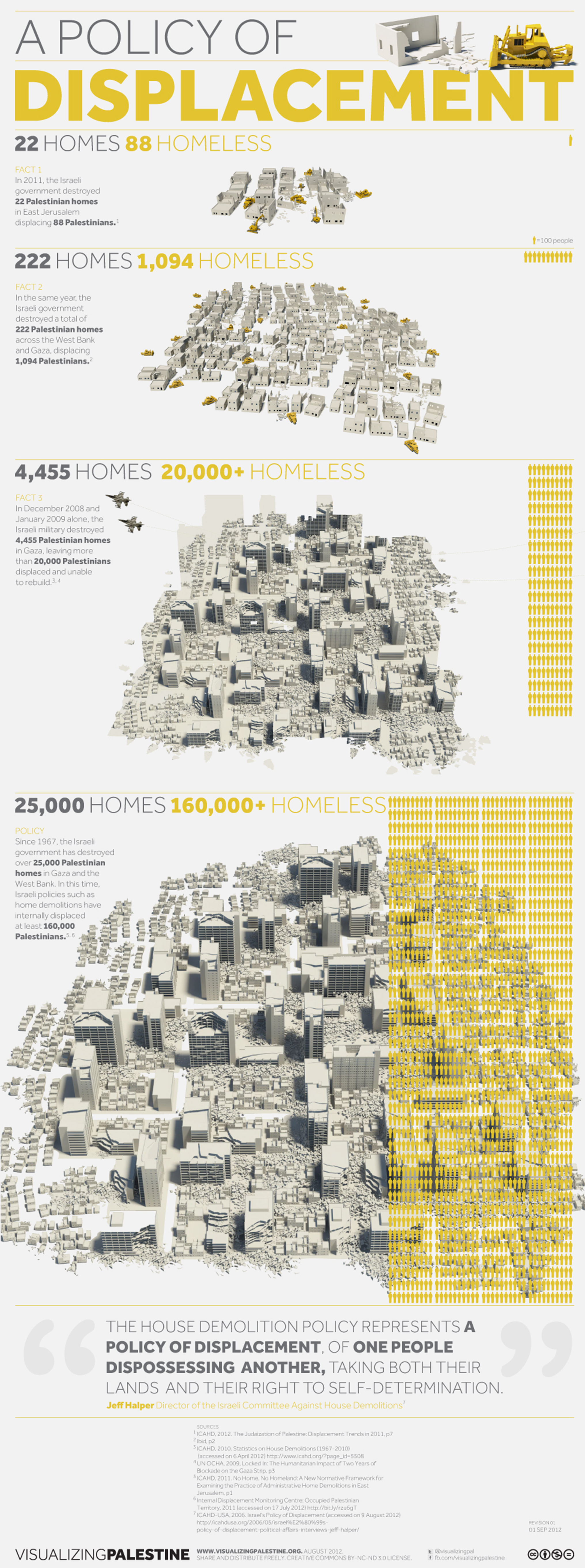
The number of Palestinian refugees and their descendants since 1948 is currently estimated to be 7 million (UNWRA), with many living in refugee camps (Lebanon, Jordan, Syria) for generations. There are multiple types of forced displacement on different scales, from the family home, neighbourhood to region and country, including the 1948 ‘Nakba’ or expulsion of the Palestinian population (into Jordan-occupied West Bank and Egypt-occupied Gaza Strip) LINK, and the 1967 war LINK. House demolition, land confiscation and the expansion of illegal settlements are Israeli state techniques of forced displacement of Palestinians1. The number of internally displaced Palestinians haven’t been systemically recorded by the Palestinian Authority (PA), so numbers may vary2, often relying on NGOs to keep track3. Though the 1947 partition or the ‘green line’ agreed by the UN was temporary, it has become the de facto border between Palestine-Israel4. However, in ongoing violation of this 1947 partition there is illegal settlement expansion onto Palestinian land allowed by the Israeli state, and a Separation Barrier built by Israel beyond the partition, with a continued evasion of border definition by Israel. There is a process of continual expansion by extending construction for Israeli infrastructure (e.g. water, electricity, communications towers) into Palestinian land, after which settlements are allowed to form.

RESTRICTED FREEDOM OF MOVEMENT
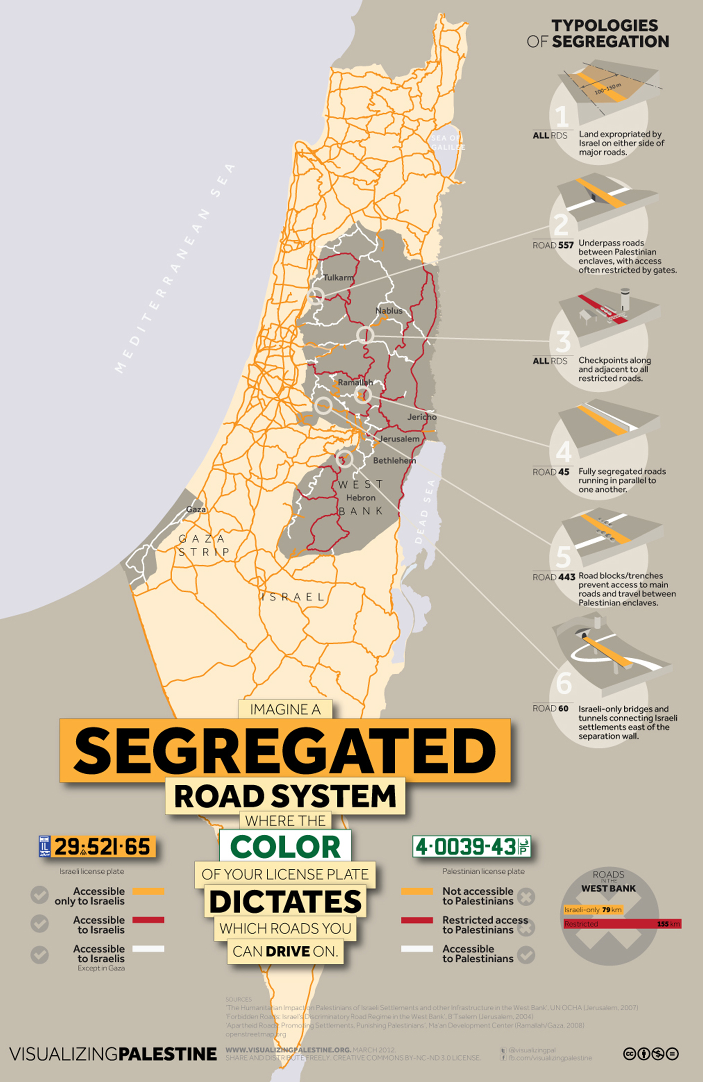
The Israeli State controls the freedom of movement of Palestinians, through a militarised separation barrier, permanent checkpoints (as well as temporary, mobile ones) and roadblocks, and requiring permits to travel within Palestine e.g from the West Bank to East Jerusalem or Gaza, or within the West Bank between zones A,B and C, including even just to see family, friends, or to go to work. Longer commute times from checkpoints and roadblocks reduces the time spent at home, at school or at work, impacting family life and education. The Israeli State controls affect all ‘bureaucratic and legal processes from birth to death’—from registering a birth, to ‘obtaining burial permits and travel permission, and the physical barriers interfering with rituals and traditions around death’5.
APARTHEID OR SEGREGATIONIST POLICIES
With an ID system in place at checkpoints, where Israeli and Palestinian citizens are subject to different levels of security checks, marriage laws preventing marriage between groups, different legal rights between and court procedures for Israeli and Palestinian citizens, effective segregation through a security wall, separate roads for Palestinians and Israeli citizens around settlements in occupied territories and segregated buses6, then Israel-Palestine could be considered— by UN definition—an Apartheid state. United Nations international law defines apartheid as ‘an institutionalised regime of systematic oppression and domination by one racial group over any other racial group or groups and committed with the intention of maintaining that regime'7. Hafrada (translating from Hebrew as separation) is the Israeli state policy of separating Israeli and Palestinian populations within the oPt, and which requires everyone to carry an Israeli issued ID card; until 2005 the Israeli ID card stated the holder’s ethnicity, and until 2015 included a code that indicated ethnicity. Israel has been described as an Apartheid state by members of the UN and government members internationally8.
The treatment of Palestinians in East Jerusalem (technically state of Israel) is as if they were effectively ‘second-class citizens’, through restricted access rights to land, jobs, and resources, and less funding towards Palestinians community education and infrastructure. Within East Jerusalem in Israel, there is largely segregated housing, and schooling is by primary language (Arabic or Hebrew), with a lower budget allocated to ‘Arabic-speaking’ schools which reinforces the unemployment cycle as a strategy of ‘disinvestment’; Palestinians earn 40% less than Israeli wages (holding the majority of service ‘blue collar’ jobs in the Israeli economy), even if they have the same or higher qualifications, are more likely to be made unemployed before other workers9. Palestinians living in East Jerusalem (Israel) are denied housing advice and services, thereby effectively being pushed out of Jerusalem10.With Israeli expansion and the ever-decreasing territory of the West Bank, rent and property prices are increasing, forcing people into poverty. Around 26% of Palestinians overall live in poverty, while in Gaza it is 39%. Economic blockades and sanctions restrict the growth of the Palestinian economy, especially in Gaza since Israel controls the border through which all goods enter and since the closure of tunnels to the neighbouring state of Egypt (2006 onwards).
INCARCERATION
Arrest of Palestinians by the IDF (Israeli Defence Force) is frequent, disproportionately effecting men and children, where approximately 1 in 5 Palestinians and 40 per cent of men have been or are currently imprisoned, and if imprisoned they’re often tortured11. They are frequently arrested for minor crimes, with a high percentage of wrongful arrests, and are often detained without a lawyer; Administrative Detention is a law where Palestinians can be imprisoned by Israel without trial12. A high number of arrests are violent, and take place during the night as part of house or building raids. After arrest they experience interrogation and torture, and Palestinians are tried in a military court separate to the ones used for Israeli citizens (civil court) and without access to legal counsel. Rather than arrests being in proportion to crime rate, it is used as an assertion of control by the Israeli state. Crimes between Palestinian communities, such as gang violence, homicide and drug dealing are problems that have increased as a result of state neglect, and are never investigated. Israeli Human Rights violations include frequent use of tear gas and rubber-coated bullets on civilians, violence or abuse from IDF soldiers at checkpoints or from people living in settlements. Children are arrested, at home and often in the middle of the night, but also at demonstrations or at checkpoints, taken to prisons in Israel with limited contact with family, interrogated and subject to physical violence, and trialled in military courts that lack fair judicial treatment. The charge is usually of throwing stones, where the conviction rate is 99% with a maximum sentence of 10-20 years13.
GAZA
The Gaza Strip is home to 1.8 million Palestinians, and is one of most densely populated areas in the world. There is widespread poverty caused by the Israeli economic blockade14which restricts essential supplies of food, clean water, medicine and electricity, and economic sanctions means they can be imported, but at a much higher cost. As a result 80% of Gaza’s population depend on humanitarian aid 15. There is highly restricted freedom of movement, where most Gazans are never officially allowed to leave Gaza, even for work, family, medical purposes, education, training or when under attack. As well as long-term and structural inequalities through occupation, in Gaza there is direct military attack through sporadic bombing campaigns causing acute humanitarian crises. In the 2014 and 2016 attacks on Gaza (as well as violence in the West Bank), 2,100 Palestinians were killed and 10,000 wounded 16 and 11,000 homes were destroyed or made uninhabitable, leading to the largest wave of internal displacement since 1967. There is a current bombing campaign at the time of writing (September-December 2020) during a global pandemic. Power and water supplies for hospitals and health centres are targeted or cut during periods of bombing. Restricted freedom of movement contributes to overcrowding in Gaza, which was projected to be ‘uninhabitable’ by 2020 by UNWRA, and house demolitions and continued bombing by Israel further reduces the amount of habitable buildings available. IDF border guards fire live ammunition at demonstrators in Gaza 17where in 2019 they killed 34 and injured 1,883 Palestinians (al-Mezan, Gaza Health Ministry). In Gaza other weapons that cause psychological distress but minimal physical destruction, include the use of sonic boom and drone surveillance. A sonic boom is an illegal tactic whereby military jets at high-speed and low altitude over airspace in Gaza are used to break the sound barrier, sending shockwaves and a loud explosion. It is used in the middle of the night to disrupt sleep, induce stress, fear and panic, and results in trauma in children (seen through anxiety disorder and bed-wetting), and miscarriages in women. Children are disproportionately effected, and increasingly suffer from PTSD, where in Gaza 32.7% of children suffer from severe levels of post-traumatic stress disorder, 49% moderate levels and 16% low levels.

FOOTNOTES
- Palestinian Counselling Centre (2009) Broken Homes: A Study on demolitions years 2000-2006
- However, UN OCHA (Coordination of Humanitarian Affairs) and BT’Selem began tracking house demolitions in 2006 (PCC, 2009:11).
- Palestinian Counselling Centre (2009)
- The Green Line: A Definition
- Nadera Shalhoub Kervorkian (2014) Living death, recovering life: psychosocial resistance and the power of the dead in East Jerusalem Intervention, Volume 12, Number 1, pp.16-29.
- B'TSelem (2004)
- United Nations Definition of Apartheid (1973)
- Report of the UN Special Rapporteur on Human Rights in the OPT (2007) John Dugard. Visualizing Palestine: Apartheid and Hafrada.
- 'Systemic Racism in the US and Israel’ A panel discussion between Nadia Abu El Haj, Johanna Fernández, Maha Nassar, and Nahla Abdo, Institute of Palestine Studies (July) 2020.
- Palestinian Counseling Centre (2012) 'With Our Own Hands: A report on what happens when Israel forces Palestinian families to demolish their own homes.'
- Dr. Samah Jabr: The 'invisible damage' of life under the occupation’(2014) MEMO: Middle East Monitor, Interview by Emmanuela Eposti
- Definition of Administrative Detention in Palestine by BT'Selem (2017)
- Military Court Watch (2017) in Palestine Solidarity Campaign: Palestinian Children in Israeli Detention
- The economic blockade on Gaza violates international law as blockades are prohibited by the Fourth Geneva Convention
- Human Rights Watch Palestine 2020 Report
- World Health Organisation Report on Palestine (2017)
- Palestinian human rights group al-Mezan in Human Rights Watch Palestine: 2020
For more detailed timelines of Palestinian history, please see Resources below.
CONTEMPORARY PALESTINE: OVERVIEW
Palestinians within the oPt face ongoing military occupation, human rights violations, displacement, apartheid or segregationist polices as well as socio-economic inequalities. These affect all areas of life from the home, family, school, community, employment and healthcare with systematic and long-term social, psychological and economic impacts across different generations of Palestinians.
In the oPt the Israeli state controls all aspects of Palestinian life; Palestinians don't have the right to vote in Israel, the state which occupies them, but can vote for parties within the Palestinian Authority (PA), but the amount of power they have is limited by Israel. The Palestinian Liberation Organisation (PLO) was founded in 1964 and internationally recognised as representative of the Palestinians people globally. The PA was established in 1994 after the Oslo Accords, and replaced the PLO as the dominant political representative. There are two main political parties in the PA: Fatah (West Bank) and Hamas (Gaza); there was an internal split in 2007 when Hamas won the vote in the Gaza strip, and are considered a more grassroots and counter-hegemonic political party. The 1st Intifada (1987-1993) and 2nd Intifada (2000-2005) were uprisings by the Palestinian people against Israeli occupation. The state of Israel has not only occupied Palestine, but at various points occupied land in neighbouring Egypt (Sinai), Syria (Golan Heights) and the south of Lebanon.
The number of Palestinian refugees and their descendants since 1948 is currently estimated to be 7 million (UNWRA), with many living in refugee camps (Lebanon, Jordan, Syria) for generations. There are multiple types of forced displacement on different scales, from the family home, neighbourhood to region and country, including the 1948 ‘Nakba’ or expulsion of the Palestinian population (into Jordan-occupied West Bank and Egypt-occupied Gaza Strip) LINK, and the 1967 war LINK. House demolition, land confiscation and the expansion of illegal settlements are Israeli state techniques of forced displacement of Palestinians1. The number of internally displaced Palestinians haven’t been systemically recorded by the Palestinian Authority (PA), so numbers may vary2, often relying on NGOs to keep track3. Though the 1947 partition or the ‘green line’ agreed by the UN was temporary, it has become the de facto border between Palestine-Israel4. However, in ongoing violation of this 1947 partition there is illegal settlement expansion onto Palestinian land allowed by the Israeli state, and a Separation Barrier built by Israel beyond the partition, with a continued evasion of border definition by Israel. There is a process of continual expansion by extending construction for Israeli infrastructure (e.g. water, electricity, communications towers) into Palestinian land, after which settlements are allowed to form.
RESTRICTED FREEDOM OF MOVEMENT
The Israeli State controls the freedom of movement of Palestinians, through a militarised separation barrier, permanent checkpoints (as well as temporary, mobile ones) and roadblocks, and requiring permits to travel within Palestine e.g from the West Bank to East Jerusalem or Gaza, or within the West Bank between zones A,B and C, including even just to see family, friends, or to go to work. Longer commute times from checkpoints and roadblocks reduces the time spent at home, at school or at work, impacting family life and education. The Israeli State controls affect all ‘bureaucratic and legal processes from birth to death’—from registering a birth, to ‘obtaining burial permits and travel permission, and the physical barriers interfering with rituals and traditions around death’5.
APARTHEID OR SEGREGATIONIST POLICIES
With an ID system in place at checkpoints, where Israeli and Palestinian citizens are subject to different levels of security checks, marriage laws preventing marriage between groups, different legal rights between and court procedures for Israeli and Palestinian citizens, effective segregation through a security wall, separate roads for Palestinians and Israeli citizens around settlements in occupied territories and segregated buses6, then Israel-Palestine could be considered— by UN definition—an Apartheid state. United Nations international law defines apartheid as ‘an institutionalised regime of systematic oppression and domination by one racial group over any other racial group or groups and committed with the intention of maintaining that regime'7. Hafrada (translating from Hebrew as separation) is the Israeli state policy of separating Israeli and Palestinian populations within the oPt, and which requires everyone to carry an Israeli issued ID card; until 2005 the Israeli ID card stated the holder’s ethnicity, and until 2015 included a code that indicated ethnicity. Israel has been described as an Apartheid state by members of the UN and government members internationally8.
The treatment of Palestinians in East Jerusalem (technically state of Israel) is as if they were effectively ‘second-class citizens’, through restricted access rights to land, jobs, and resources, and less funding towards Palestinians community education and infrastructure. Within East Jerusalem in Israel, there is largely segregated housing, and schooling is by primary language (Arabic or Hebrew), with a lower budget allocated to ‘Arabic-speaking’ schools which reinforces the unemployment cycle as a strategy of ‘disinvestment’; Palestinians earn 40% less than Israeli wages (holding the majority of service ‘blue collar’ jobs in the Israeli economy), even if they have the same or higher qualifications, are more likely to be made unemployed before other workers9. Palestinians living in East Jerusalem (Israel) are denied housing advice and services, thereby effectively being pushed out of Jerusalem10.With Israeli expansion and the ever-decreasing territory of the West Bank, rent and property prices are increasing, forcing people into poverty. Around 26% of Palestinians overall live in poverty, while in Gaza it is 39%. Economic blockades and sanctions restrict the growth of the Palestinian economy, especially in Gaza since Israel controls the border through which all goods enter and since the closure of tunnels to the neighbouring state of Egypt (2006 onwards).
INCARCERATION
Arrest of Palestinians by the IDF (Israeli Defence Force) is frequent, disproportionately effecting men and children, where approximately 1 in 5 Palestinians and 40 per cent of men have been or are currently imprisoned, and if imprisoned they’re often tortured11. They are frequently arrested for minor crimes, with a high percentage of wrongful arrests, and are often detained without a lawyer; Administrative Detention is a law where Palestinians can be imprisoned by Israel without trial12. A high number of arrests are violent, and take place during the night as part of house or building raids. After arrest they experience interrogation and torture, and Palestinians are tried in a military court separate to the ones used for Israeli citizens (civil court) and without access to legal counsel. Rather than arrests being in proportion to crime rate, it is used as an assertion of control by the Israeli state. Crimes between Palestinian communities, such as gang violence, homicide and drug dealing are problems that have increased as a result of state neglect, and are never investigated. Israeli Human Rights violations include frequent use of tear gas and rubber-coated bullets on civilians, violence or abuse from IDF soldiers at checkpoints or from people living in settlements. Children are arrested, at home and often in the middle of the night, but also at demonstrations or at checkpoints, taken to prisons in Israel with limited contact with family, interrogated and subject to physical violence, and trialled in military courts that lack fair judicial treatment. The charge is usually of throwing stones, where the conviction rate is 99% with a maximum sentence of 10-20 years13.
GAZA
The Gaza Strip is home to 1.8 million Palestinians, and is one of most densely populated areas in the world. There is widespread poverty caused by the Israeli economic blockade14which restricts essential supplies of food, clean water, medicine and electricity, and economic sanctions means they can be imported, but at a much higher cost. As a result 80% of Gaza’s population depend on humanitarian aid 15. There is highly restricted freedom of movement, where most Gazans are never officially allowed to leave Gaza, even for work, family, medical purposes, education, training or when under attack. As well as long-term and structural inequalities through occupation, in Gaza there is direct military attack through sporadic bombing campaigns causing acute humanitarian crises. In the 2014 and 2016 attacks on Gaza (as well as violence in the West Bank), 2,100 Palestinians were killed and 10,000 wounded 16 and 11,000 homes were destroyed or made uninhabitable, leading to the largest wave of internal displacement since 1967. There is a current bombing campaign at the time of writing (September-December 2020) during a global pandemic. Power and water supplies for hospitals and health centres are targeted or cut during periods of bombing. Restricted freedom of movement contributes to overcrowding in Gaza, which was projected to be ‘uninhabitable’ by 2020 by UNWRA, and house demolitions and continued bombing by Israel further reduces the amount of habitable buildings available. IDF border guards fire live ammunition at demonstrators in Gaza 17where in 2019 they killed 34 and injured 1,883 Palestinians (al-Mezan, Gaza Health Ministry). In Gaza other weapons that cause psychological distress but minimal physical destruction, include the use of sonic boom and drone surveillance. A sonic boom is an illegal tactic whereby military jets at high-speed and low altitude over airspace in Gaza are used to break the sound barrier, sending shockwaves and a loud explosion. It is used in the middle of the night to disrupt sleep, induce stress, fear and panic, and results in trauma in children (seen through anxiety disorder and bed-wetting), and miscarriages in women. Children are disproportionately effected, and increasingly suffer from PTSD, where in Gaza 32.7% of children suffer from severe levels of post-traumatic stress disorder, 49% moderate levels and 16% low levels.
FOOTNOTES
- Palestinian Counselling Centre (2009) Broken Homes: A Study on demolitions years 2000-2006
- However, UN OCHA (Coordination of Humanitarian Affairs) and BT’Selem began tracking house demolitions in 2006 (PCC, 2009:11).
- Palestinian Counselling Centre (2009)
- The Green Line: A Definition
- Nadera Shalhoub Kervorkian (2014) Living death, recovering life: psychosocial resistance and the power of the dead in East Jerusalem Intervention, Volume 12, Number 1, pp.16-29.
- B'TSelem (2004)
- United Nations Definition of Apartheid (1973)
- Report of the UN Special Rapporteur on Human Rights in the OPT (2007) John Dugard. Visualizing Palestine: Apartheid and Hafrada.
- 'Systemic Racism in the US and Israel’ A panel discussion between Nadia Abu El Haj, Johanna Fernández, Maha Nassar, and Nahla Abdo, Institute of Palestine Studies (July) 2020.
- Palestinian Counseling Centre (2012) 'With Our Own Hands: A report on what happens when Israel forces Palestinian families to demolish their own homes.'
- Dr. Samah Jabr: The 'invisible damage' of life under the occupation’(2014) MEMO: Middle East Monitor, Interview by Emmanuela Eposti
- Definition of Administrative Detention in Palestine by BT'Selem (2017)
- Military Court Watch (2017) in Palestine Solidarity Campaign: Palestinian Children in Israeli Detention
- The economic blockade on Gaza violates international law as blockades are prohibited by the Fourth Geneva Convention
- Human Rights Watch Palestine 2020 Report
- World Health Organisation Report on Palestine (2017)
- Palestinian human rights group al-Mezan in Human Rights Watch Palestine: 2020